
Mollie-Margot topographic map
Interactive map
Click on the map to display elevation.
About this map
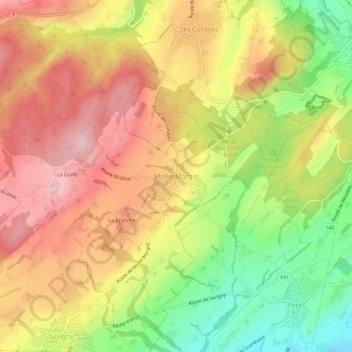
Name: Mollie-Margot topographic map, elevation, terrain.
Average elevation: 809 m
Minimum elevation: 685 m
Maximum elevation: 909 m
Other topographic maps
Click on a map to view its topography, its elevation and its terrain.
La Branche
Suisse > Vaud > District de Lavaux-Oron > Mollie-Margot
La Branche, Mollie-Margot, Savigny, District de Lavaux-Oron, Vaud, 1073, Suisse
Average elevation: 814 m
La Goille
Suisse > Vaud > District de Lavaux-Oron > Mollie-Margot > La Goille
La Goille, Mollie-Margot, Savigny, District de Lavaux-Oron, Vaud, 1073, Suisse
Average elevation: 837 m