
Gooreind topographic map
Interactive map
Click on the map to display elevation.
About this map
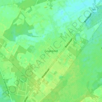
Name: Gooreind topographic map, elevation, terrain.
Location: Gooreind, Wuustwezel, Antwerpen, Vlaanderen, België (51.33616 4.52292 51.37616 4.56292)
Average elevation: 23 m
Minimum elevation: 16 m
Maximum elevation: 28 m
Other topographic maps
Click on a map to view its topography, its elevation and its terrain.
Wuustwezel
België > Antwerpen > Antwerpen > Wuustwezel
Wuustwezel, Antwerpen, Vlaanderen, België
Average elevation: 19 m
Loenhout
België > Antwerpen > Antwerpen > Wuustwezel
Loenhout, Wuustwezel, Antwerpen, Vlaanderen, België
Average elevation: 16 m