
Makhatchkala topographic map
Interactive map
Click on the map to display elevation.
About this map
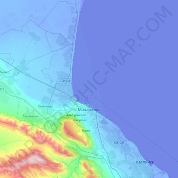
Name: Makhatchkala topographic map, elevation, terrain.
Average elevation: 57 m
Minimum elevation: -30 m
Maximum elevation: 884 m
Other topographic maps
Click on a map to view its topography, its elevation and its terrain.
Семендер
Russie > Daghestan > городской округ Махачкала > Семендер
Семендер, Кировский район, городской округ Махачкала, Daghestan, District fédéral du Caucase du Nord, 367006, Russie
Average elevation: 22 m