
Neath Port Talbot topographic map
Interactive map
Click on the map to display elevation.
About this map
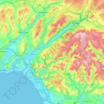
Name: Neath Port Talbot topographic map, elevation, terrain.
Location: Neath Port Talbot, Wales, VK (51.52672 -3.93630 51.81040 -3.56187)
Average elevation: 188 m
Minimum elevation: -4 m
Maximum elevation: 603 m
Other topographic maps
Click on a map to view its topography, its elevation and its terrain.
Brecon Beacons
Brecon Beacons, A470, Cwm-llwch, Powys, Wales, LD3 8NL, VK
Average elevation: 270 m
Afan Forest
Afan Forest, W², Ton-Mawr, Neath Port Talbot, Wales, SA13 3HH, VK
Average elevation: 255 m
Llangollen
VK > Wales > Llangollen
Llangollen, Denbighshire, Wales, LL20 8PS, VK
Average elevation: 279 m