
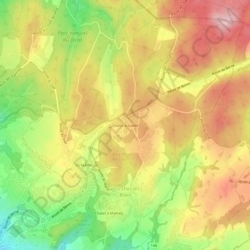
Chalet-à-Gobet topographic map
Interactive map
Click on the map to display elevation.
About this map
Name: Chalet-à-Gobet topographic map, elevation, terrain.
Average elevation: 847 m
Minimum elevation: 733 m
Maximum elevation: 941 m
Other topographic maps
Click on a map to view its topography, its elevation and its terrain.
Chalet à Mathey
Suisse > Vaud > District de Lausanne > Lausanne
Chalet à Mathey, Lausanne, District de Lausanne, Vaud, 1000, Suisse
Average elevation: 808 m
Montheron
Suisse > Vaud > District de Lausanne > Lausanne
Montheron, Lausanne, District de Lausanne, Vaud, 1055, Suisse
Average elevation: 780 m
En Marin
Suisse > Vaud > District de Lausanne > Lausanne
En Marin, Lausanne, District de Lausanne, Vaud, 1000, Suisse
Average elevation: 818 m
Montblesson
Suisse > Vaud > District de Lausanne > Lausanne
Montblesson, Lausanne, District de Lausanne, Vaud, 1068, Suisse
Average elevation: 746 m