
Denver topographic map
Interactive map
Click on the map to display elevation.
About this map
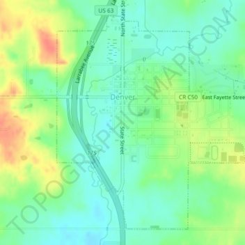
Name: Denver topographic map, elevation, terrain.
Location: Denver, Bremer County, Iowa, 50622, États-Unis d'Amérique (42.65680 -92.34714 42.68031 -92.31754)
Average elevation: 298 m
Minimum elevation: 280 m
Maximum elevation: 327 m
Other topographic maps
Click on a map to view its topography, its elevation and its terrain.
Denver
États-Unis d'Amérique > Iowa > Bremer County > Denver
Denver, Bremer County, Iowa, 50622, États-Unis d'Amérique
Average elevation: 301 m