
Thank you for supporting this site ❤️
Make a donation
Make a donation
Chania topographic map
Click on the map to display elevation.
Thank you for supporting this site ❤️
Make a donation
Make a donation
Chania
The climate in Chania is further complemented due to the terrain and can vary throughout its regions and elevations and according to its topography. At the south lies the mountain range of Lefka Ori. Furthermore, prevailing winds, such as those of the West side and South of Crete, in addition to the North side—all interact to form its climate.
Thank you for supporting this site ❤️
Make a donation
Make a donation
About this map
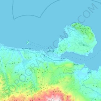
Name: Chania topographic map, elevation, terrain.
Average elevation: 194 m
Minimum elevation: -1 m
Maximum elevation: 2,051 m
Thank you for supporting this site ❤️
Make a donation
Make a donation
Other topographic maps
Click on a map to view its topography, its elevation and its terrain.
Municipality of Kantanos-Selinon
Greece > Region of Crete > Chania Regional Unit
Average elevation: 389 m
Thank you for supporting this site ❤️
Make a donation
Make a donation
Municipality of Kantanos-Selinon
Greece > Region of Crete > Chania Regional Unit
Average elevation: 389 m
Thank you for supporting this site ❤️
Make a donation
Make a donation
Thank you for supporting this site ❤️
Make a donation
Make a donation
Thank you for supporting this site ❤️
Make a donation
Make a donation