
Mottec topographic map
Interactive map
Click on the map to display elevation.
About this map
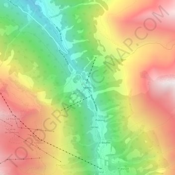
Name: Mottec topographic map, elevation, terrain.
Location: Mottec, Anniviers, Sierre, Valais/Wallis, 3961, Zwitserland (46.13671 7.59987 46.17671 7.63987)
Average elevation: 2,100 m
Minimum elevation: 1,345 m
Maximum elevation: 2,888 m
Other topographic maps
Click on a map to view its topography, its elevation and its terrain.
Zinal
Zwitserland > Valais/Wallis > Sierre > Anniviers
Zinal, Anniviers, Sierre, Valais/Wallis, 3961, Zwitserland
Average elevation: 2,209 m