
Thank you for supporting this site ❤️
Make a donation
Make a donation
Maturana topographic map
Click on the map to display elevation.
Thank you for supporting this site ❤️
Make a donation
Make a donation
About this map
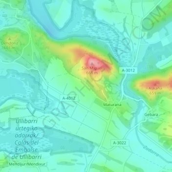
Name: Maturana topographic map, elevation, terrain.
Average elevation: 562 m
Minimum elevation: 534 m
Maximum elevation: 660 m
Thank you for supporting this site ❤️
Make a donation
Make a donation
Other topographic maps
Click on a map to view its topography, its elevation and its terrain.
Gebara
Spain > Autonomous Community of the Basque Country > Arabako lautada/Llanada Alavesa
Average elevation: 574 m
Fuente Oneri
Spain > Autonomous Community of the Basque Country > Arabako lautada/Llanada Alavesa > Agurain/Salvatierra
Average elevation: 681 m