
Thank you for supporting this site ❤️
Make a donation
Make a donation
Saltair topographic map
Click on the map to display elevation.
Thank you for supporting this site ❤️
Make a donation
Make a donation
About this map
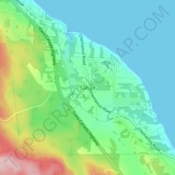
Name: Saltair topographic map, elevation, terrain.
Average elevation: 66 m
Minimum elevation: -1 m
Maximum elevation: 257 m
Thank you for supporting this site ❤️
Make a donation
Make a donation
Other topographic maps
Click on a map to view its topography, its elevation and its terrain.
Thetis Island
Canada > British Columbia > Cowichan Valley Regional District > Area G (Saltair / Gulf Islands) > Spune’luxutth
Average elevation: 16 m
Valdes Island
Canada > British Columbia > Cowichan Valley Regional District > Area G (Saltair / Gulf Islands)
Average elevation: 11 m