
Make a donation
Gschnitz topographic map
Click on the map to display elevation.
Make a donation
Gschnitz
The Sanctuary of St. Magdalena is located near the border, between Gschnitz and Trins, at an altitude of 1,661 m (5,449 ft) accessible only on foot, under the Schönberg. The church is the oldest in the valley as confirmed by the Romanesque frescoes dating back around 1200 and discovered in 1959.
Make a donation
About this map
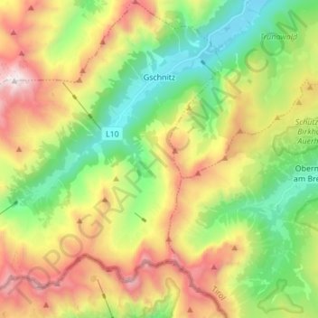
Name: Gschnitz topographic map, elevation, terrain.
Location: Gschnitz, Bezirk Innsbruck-Land, Tyrol, Austria (46.97391 11.24207 47.06724 11.37934)
Average elevation: 2,017 m
Minimum elevation: 1,202 m
Maximum elevation: 3,239 m
Make a donation
Other topographic maps
Click on a map to view its topography, its elevation and its terrain.
Hoher Burgstall
Austria > Tyrol > Bezirk Innsbruck-Land > Neustift im Stubaital
Average elevation: 2,142 m
Make a donation
Make a donation
Elferspitze
Austria > Tyrol > Bezirk Innsbruck-Land > Neustift im Stubaital
Average elevation: 1,978 m
Make a donation
Make a donation
Axamer Lizum
Austria > Tyrol > Bezirk Innsbruck-Land > Gemeinde Axams > Axamer Lizum
Average elevation: 1,858 m
Make a donation