
Make a donation
Dunstable topographic map
Click on the map to display elevation.
Make a donation
About this map
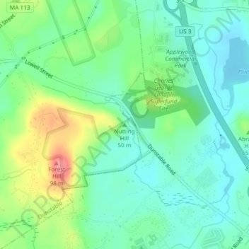
Name: Dunstable topographic map, elevation, terrain.
Average elevation: 60 m
Minimum elevation: 34 m
Maximum elevation: 118 m
Make a donation
Other topographic maps
Click on a map to view its topography, its elevation and its terrain.
Freeman Lake
United States > Massachusetts > Middlesex County > Chelmsford > North Chelmsford
Average elevation: 40 m
Make a donation
Ashby
United States > Massachusetts > Middlesex County
Mount Watatic was also once home to state fire tower #31 that looked out over central Massachusetts at an elevation above sea level of 1590 FT. Phone lines to the tower ran up the Ashby and Ashburnham sides of the mountain over the years.
Average elevation: 265 m
Waitts Mount
United States > Massachusetts > Middlesex County > Malden > Malden Centre
Average elevation: 22 m
Make a donation
Hopkinton Reservoir
United States > Massachusetts > Middlesex County > Hopkinton
Average elevation: 111 m
Make a donation
Lake Mascuppic
United States > Massachusetts > Middlesex County > Tyngsborough > Willowdale
Average elevation: 57 m
Bridge Meadow Brook
United States > Massachusetts > Middlesex County > Tyngsborough
Average elevation: 60 m
Make a donation