
Puno topographic map
Click on the map to display elevation.
About this map
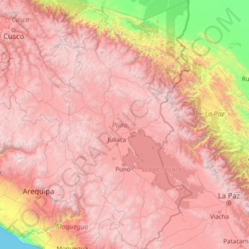
Name: Puno topographic map, elevation, terrain.
Location: Puno, Peru (-17.29525 -71.11809 -13.00413 -68.79549)
Average elevation: 3,150 m
Minimum elevation: 0 m
Maximum elevation: 6,251 m
Other topographic maps
Click on a map to view its topography, its elevation and its terrain.
La Rinconada
High in the Andes, La Rinconada has an alpine tundra climate (ET, according to the Köppen climate classification), with no month having mean temperatures even close to the 10 °C (50 °F) threshold that would permit tree growth and a subtropical highland classification for the city. Far above the tree line,…
Average elevation: 4,923 m
Cuzco
Cusco or Cuzco (Spanish: [ˈkusko]; Quechua: Qosqo or Qusqu, pronounced [ˈqɔsqɔ]) is a city in southeastern Peru, near the Sacred Valley of the Andes mountain range and the Huatanay river. It is the capital of the eponymous province and department. The city is the seventh most populous in Peru; in 2017, it…
Average elevation: 3,790 m