
Make a donation
French Guiana topographic map
Click on the map to display elevation.
Make a donation
French Guiana
French Guiana has an equatorial climate predominant. Located within six degrees of the Equator and rising only to modest elevations, French Guiana is hot and oppressively humid all year round. During most of the year, rainfall across the country is heavy due to the presence of the Intertropical Convergence Zone and its powerful thunderstorm cells. In most parts of French Guiana, rainfall is always heavy especially from December to July – typically over 330 millimetres or 13 inches can be expected each month during this period throughout the department. Between August and November, the eastern half experiences a warm dry season with rainfall below 100 millimetres or 3.94 inches and average high temperatures above 30 °C (86 °F) occurring in September and October, causing eastern French Guiana to be classified as a tropical monsoon climate (Köppen Am); Saint-Laurent-du-Maroni in the west has a tropical rainforest climate (Af).
Make a donation
About this map
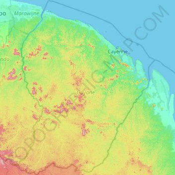
Name: French Guiana topographic map, elevation, terrain.
Location: French Guiana, France (2.11094 -54.60269 5.98389 -51.50452)
Average elevation: 96 m
Minimum elevation: -2 m
Maximum elevation: 791 m
Make a donation
Other topographic maps
Click on a map to view its topography, its elevation and its terrain.
Valence
France > Auvergne-Rhône-Alpes > Drôme
The area of the commune is 3,669 hectares (9,070 acres), representing 36.69 square kilometres (14.17 sq mi); the altitude varies between 106–191 metres (348–627 ft).
Average elevation: 287 m
Make a donation
La Villa Trévi
France > Auvergne-Rhône-Alpes > Upper Savoy > Épagny Metz-Tessy
Average elevation: 493 m
Cime de la Bonette
France > Provence-Alpes-Côte d'Azur > Maritime Alps > Saint-Dalmas-le-Selvage
Average elevation: 2,512 m
Make a donation
Aurafrède
France > Provence-Alpes-Côte d'Azur > Alpes-de-Haute-Provence > Gréoux-les-Bains
Average elevation: 389 m
Make a donation
Les Eschartès
France > Nouvelle-Aquitaine > Pyrénées-Atlantiques > Louvie-Soubiron
Average elevation: 942 m
Champ
France > Auvergne-Rhône-Alpes > Ardèche > Saint-Romain-de-Lerps > Roussiveyrent
Average elevation: 501 m
Make a donation
Make a donation
Fatu Huku
France > French Polynesia > Marquesas Islands > Hiva Oa
The island is essentially a huge rock, looming steep-sided out of the ocean and rising to a flattened plateau with a maximum elevation of 361 metres (1,184 ft). Fatu Huku is the youngest of the volcanic Marquesas Islands, estimated to be only 1.3 million years old which accounts, in part, for its ruggedness as…
Average elevation: 8 m
Make a donation
Agusan
France > New Aquitaine > Lot-et-Garonne > Laplume > Laplatrière de Bordeneuve
Average elevation: 159 m
Make a donation