
Thank you for supporting this site ❤️
Make a donation
Make a donation
Patersberg topographic map
Click on the map to display elevation.
Thank you for supporting this site ❤️
Make a donation
Make a donation
About this map
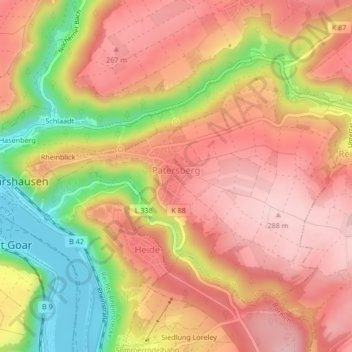
Name: Patersberg topographic map, elevation, terrain.
Average elevation: 209 m
Minimum elevation: 71 m
Maximum elevation: 291 m
Thank you for supporting this site ❤️
Make a donation
Make a donation
Other topographic maps
Click on a map to view its topography, its elevation and its terrain.
Burg Hohlenfels
Germany > Rhineland-Palatinate > Rhein-Lahn-Kreis > Mudershausen
Average elevation: 282 m