
Thank you for supporting this site ❤️
Make a donation
Make a donation
Couthuin topographic map
Click on the map to display elevation.
Thank you for supporting this site ❤️
Make a donation
Make a donation
About this map
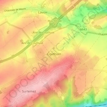
Name: Couthuin topographic map, elevation, terrain.
Location: Couthuin, Héron, Huy, Liège, Wallonie, 4217, Belgique (50.51309 5.11229 50.55309 5.15229)
Average elevation: 162 m
Minimum elevation: 69 m
Maximum elevation: 221 m
Thank you for supporting this site ❤️
Make a donation
Make a donation
Other topographic maps
Click on a map to view its topography, its elevation and its terrain.
Thank you for supporting this site ❤️
Make a donation
Make a donation