
Strzyżów County topographic map
Interactive map
Click on the map to display elevation.
About this map
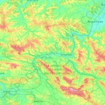
Name: Strzyżów County topographic map, elevation, terrain.
Location: Strzyżów County, Subcarpathian Voivodeship, Poland (49.78109 21.47652 49.97284 22.02207)
Average elevation: 302 m
Minimum elevation: 195 m
Maximum elevation: 584 m
Other topographic maps
Click on a map to view its topography, its elevation and its terrain.
Czudec
Poland > Subcarpathian Voivodeship > Strzyżów County
Czudec, gmina Czudec, Strzyżów County, Subcarpathian Voivodeship, Poland
Average elevation: 271 m
Bieszczady County
Poland > Subcarpathian Voivodeship
Bieszczady County, Subcarpathian Voivodeship, Poland
Average elevation: 554 m
Czudec
Poland > Subcarpathian Voivodeship > Czudec
Czudec, gmina Czudec, powiat strzyżowski, Subcarpathian Voivodeship, 38120, Poland
Average elevation: 248 m
Strzyżów
Poland > Subcarpathian Voivodeship > Strzyżów
Strzyżów, gmina Strzyżów, powiat strzyżowski, Subcarpathian Voivodeship, 38-100, Poland
Average elevation: 268 m