
Make a donation
Punta della Croce topographic map
Click on the map to display elevation.
Make a donation
About this map
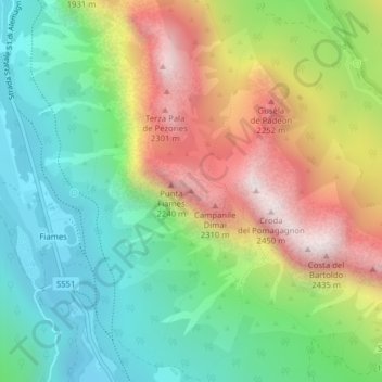
Name: Punta della Croce topographic map, elevation, terrain.
Average elevation: 1,700 m
Minimum elevation: 1,271 m
Maximum elevation: 2,367 m
Make a donation
Other topographic maps
Click on a map to view its topography, its elevation and its terrain.
Lago del Sorapíss
Italia > Veneto > Belluno > Cortina d'Ampezzo
Il lago di Sorapiss (Lago de Sorapisc in ladino) è un lago naturale posto nel contesto del Gruppo del Sorapiss nelle Dolomiti, in provincia di Belluno, ad un'altitudine di 1925 metri sul livello del mare.
Average elevation: 2,249 m
Tofane
Italia > Veneto > Belluno > Cortina d'Ampezzo
Costruita nella seconda metà del XX secolo e divisa in tre tronconi, la funivia Freccia nel Cielo è il più diretto mezzo di trasporto per raggiungere la cima della Tofana di Mezzo. La base (1.250 m s.l.m.), o prima stazione, si trova infatti nel pieno centro di Cortina, proprio davanti al famoso Stadio…
Average elevation: 2,295 m
Gruppo delle Tofane
Italia > Veneto > Belluno > Cortina d'Ampezzo
Costruita nella seconda metà del XX secolo e divisa in tre tronconi, la funivia Freccia nel Cielo è il più diretto mezzo di trasporto per raggiungere la cima della Tofana di Mezzo. La base (1.250 m s.l.m.), o prima stazione, si trova infatti nel pieno centro di Cortina, proprio davanti al famoso Stadio…
Average elevation: 1,893 m
Zuel di Sotto
Italia > Veneto > Belluno > Cortina d'Ampezzo
Zuel (Śuel in ladino) è un villaggio nel comune di Cortina d'Ampezzo, in provincia di Belluno. L'altitudine media è di 1.154 m.
Average elevation: 1,222 m
Make a donation