
Make a donation
Westchester Valley topographic map
Click on the map to display elevation.
Make a donation
About this map
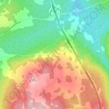
Name: Westchester Valley topographic map, elevation, terrain.
Average elevation: 194 m
Minimum elevation: 92 m
Maximum elevation: 309 m
Make a donation
Other topographic maps
Click on a map to view its topography, its elevation and its terrain.
West Wentworth
Canada > Nova Scotia > Municipality of the County of Cumberland
Average elevation: 67 m
Oxford Junction
Canada > Nova Scotia > Municipality of the County of Cumberland
Average elevation: 42 m
Make a donation
West Wentworth
Canada > Nova Scotia > Municipality of the County of Cumberland
Average elevation: 67 m
Make a donation
Make a donation
Make a donation
Greenville Station
Canada > Nova Scotia > Municipality of the County of Cumberland
Average elevation: 93 m
Make a donation
Make a donation
Advocate Harbour
Canada > Nova Scotia > Municipality of the County of Cumberland
Average elevation: 41 m
Malagash Centre
Canada > Nova Scotia > Municipality of the County of Cumberland
Average elevation: 10 m
Make a donation
East Southampton
Canada > Nova Scotia > Municipality of the County of Cumberland
Average elevation: 58 m
East Mapleton
Canada > Nova Scotia > Municipality of the County of Cumberland
Average elevation: 186 m
West Leicester
Canada > Nova Scotia > Municipality of the County of Cumberland
Average elevation: 114 m
Make a donation
Make a donation
Make a donation
Make a donation
Diligent River
Canada > Nova Scotia > Municipality of the County of Cumberland
Average elevation: 99 m
Make a donation
Make a donation
Tidnish Cross Road
Canada > Nova Scotia > Municipality of the County of Cumberland
Average elevation: 17 m
Make a donation