Bruil (Capoluogo) topographic map
Interactive map
Click on the map to display elevation.
About this map
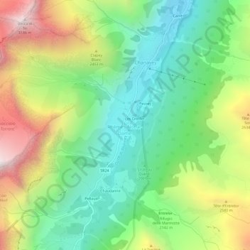
Name: Bruil (Capoluogo) topographic map, elevation, terrain.
Average elevation: 2,211 m
Minimum elevation: 1,631 m
Maximum elevation: 3,183 m

Click on the map to display elevation.
Name: Bruil (Capoluogo) topographic map, elevation, terrain.
Average elevation: 2,211 m
Minimum elevation: 1,631 m
Maximum elevation: 3,183 m