
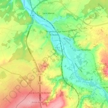
Argenton-sur-Creuse topographic map
Interactive map
Click on the map to display elevation.
About this map
Name: Argenton-sur-Creuse topographic map, elevation, terrain.
Average elevation: 164 m
Minimum elevation: 97 m
Maximum elevation: 252 m
Other topographic maps
Click on a map to view its topography, its elevation and its terrain.
Concremiers
France > Centre-Val de Loire > Indre
Concremiers, Le Blanc, Indre, Centre-Val de Loire, France métropolitaine, 36300, France
Average elevation: 112 m
Chazelet
France > Centre-Val de Loire > Indre
Chazelet, Le Blanc, Indre, Centre-Val de Loire, France métropolitaine, 36170, France
Average elevation: 203 m
Abloux
France > Centre-Val de Loire > Indre > Saint-Gilles
Abloux, Saint-Gilles, Le Blanc, Indre, Centre-Val de Loire, France métropolitaine, 36170, France
Average elevation: 207 m
Bélâbre
France > Centre-Val de Loire > Indre
Bélâbre, Le Blanc, Indre, Centre-Val de Loire, France métropolitaine, 36370, France
Average elevation: 126 m
Rolnier
France > Centre-Val de Loire > Indre > Concremiers > Rolnier
Rolnier, Concremiers, Le Blanc, Indre, Centre-Val de Loire, France métropolitaine, 36300, France
Average elevation: 106 m