
Savannakhet Province topographic map
Interactive map
Click on the map to display elevation.
About this map
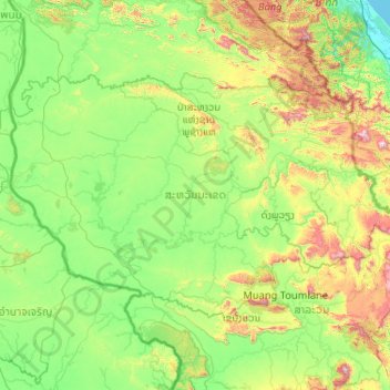
Name: Savannakhet Province topographic map, elevation, terrain.
Location: Savannakhet Province, Laos (15.87679 104.73328 17.12345 106.79878)
Average elevation: 271 m
Minimum elevation: 0 m
Maximum elevation: 1,588 m
Other topographic maps
Click on a map to view its topography, its elevation and its terrain.
Vientiane Capital
Laos > Vientiane Prefecture > Chanthabuly District
Vientiane Capital, Chanthabuly District, Vientiane Prefecture, Laos
Average elevation: 187 m
Luang Prabang
Laos > Luang Prabang > Luang Prabang District
Luang Prabang, Luang Prabang District, Luang Prabang, 10000, Laos
Average elevation: 557 m
Ban Sokpaluang
Laos > Vientiane Prefecture > Sisattanak District
Saphanthong Village, Ban Sokpaluang, Sisattanak District, Vientiane Prefecture, 01030, Laos
Average elevation: 170 m