
Thank you for supporting this site ❤️
Make a donation
Make a donation
Canicattì topographic map
Click on the map to display elevation.
Thank you for supporting this site ❤️
Make a donation
Make a donation
About this map
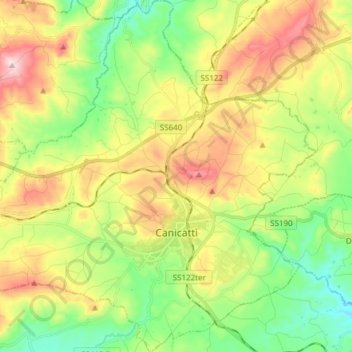
Name: Canicattì topographic map, elevation, terrain.
Location: Canicattì, Agrigento, Sicily, 92024, Italy (37.31805 13.76102 37.43820 13.91046)
Average elevation: 456 m
Minimum elevation: 279 m
Maximum elevation: 720 m
Thank you for supporting this site ❤️
Make a donation
Make a donation
Other topographic maps
Click on a map to view its topography, its elevation and its terrain.