
Pico Vallehondo topographic map
Interactive map
Click on the map to display elevation.
About this map
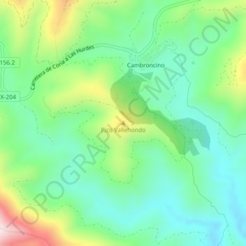
Name: Pico Vallehondo topographic map, elevation, terrain.
Location: Pico Vallehondo, Caminomorisco, Cáceres, Extremadura, España (40.33518 -6.24021 40.33528 -6.24011)
Average elevation: 532 m
Minimum elevation: 404 m
Maximum elevation: 814 m
Other topographic maps
Click on a map to view its topography, its elevation and its terrain.
Meandro del Melero
España > Extremadura > Caminomorisco
Meandro del Melero, Caminomorisco, Las Hurdes, Cáceres, Extremadura, España
Average elevation: 490 m