
Make a donation
Seealpsee topographic map
Click on the map to display elevation.
Make a donation
Seealpsee
Seealpsee is a lake in the Alpstein range of the canton of Appenzell Innerrhoden, Switzerland. At an elevation of 1,143.2 m, the surface area is 13.6 hectares (34 acres). The lake can be reached by foot from Wasserauen or from Ebenalp. It is a popular tourist destination. A network of routes around Ebenalp connects Seealpsee with other notable sights in the Appenzell Alps, such as the Wildkirchli and Säntis. The Seealpsee provides hydroelectric power and drinking water to the town of Appenzell through the Kraftwerk Seealpsee-Wasserauen [de], which is run by the Feuerschaugemeinde.
Make a donation
About this map
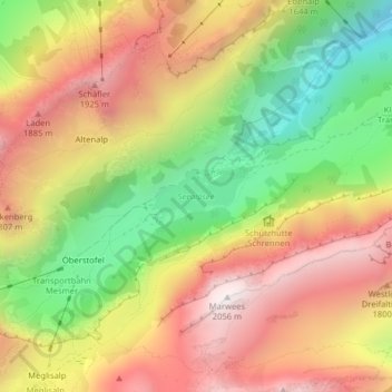
Name: Seealpsee topographic map, elevation, terrain.
Average elevation: 1,491 m
Minimum elevation: 900 m
Maximum elevation: 2,035 m
Make a donation
Other topographic maps
Click on a map to view its topography, its elevation and its terrain.
Blüemlisalp
Switzerland > Appenzell Innerrhoden > Schwende-Rüte > Wasserauen
Average elevation: 1,208 m
Make a donation