
Make a donation
Mesopotamia topographic map
Click on the map to display elevation.
Make a donation
About this map
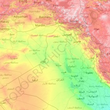
Name: Mesopotamia topographic map, elevation, terrain.
Location: Mesopotamia, Iraq (30.91048 37.83444 38.89591 47.45340)
Average elevation: 724 m
Minimum elevation: 1 m
Maximum elevation: 3,640 m
Make a donation
Other topographic maps
Click on a map to view its topography, its elevation and its terrain.
Make a donation
Make a donation
Make a donation
Umm al Binni lake
Based on the interpretation of satellite imagery, Sharad Master suggests the 3.4 km (2.1 mi) in diameter dry lake may be an impact crater based on its nearly circular, slightly polygonal rim shape, and contrasting shape to other lakes in the region. However, the circularity of its shape has been disputed, with…
Average elevation: 2 m
Make a donation
Make a donation
Halabja
Iraq > Halabja Governorate > Halabja District
Halabja is located in the Shahrizor plain, a fertile valley nestled in the foothills of the Zagros Mountains in the Kurdistan Region of Iraq. The city's elevation is around 700 meters above sea level. The surrounding area is characterized by mountainous terrain, with the Hawraman Mountain range to the east,…
Average elevation: 901 m
Make a donation
Make a donation
Ranya
Iraq > Sulaymaniyah Governorate
Ranya is located in the Sulaymaniyah Governorate in the Kurdistan Region of Iraq, approximately 70 km northeast of Sulaymaniyah city. It is situated near the Hawraman Mountains and lies at an altitude of about 1,300 meters.
Average elevation: 678 m
Make a donation
Make a donation
Make a donation
Make a donation
Make a donation
Make a donation
Make a donation
Make a donation
Make a donation
Make a donation
Make a donation
Make a donation
Make a donation
Make a donation
Make a donation
Make a donation
Make a donation
Make a donation