
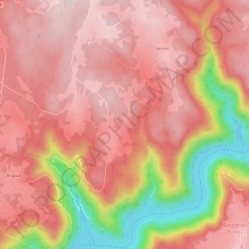
Le Mas topographic map
Interactive map
Click on the map to display elevation.
About this map
Name: Le Mas topographic map, elevation, terrain.
Average elevation: 482 m
Minimum elevation: 255 m
Maximum elevation: 579 m
Other topographic maps
Click on a map to view its topography, its elevation and its terrain.
Vergne
France > Nouvelle-Aquitaine > Corrèze > Marcillac-la-Croisille
Vergne, Marcillac-la-Croisille, Ussel, Corrèze, Nouvelle-Aquitaine, France métropolitaine, 19320, France
Average elevation: 522 m
Nougein
France > Nouvelle-Aquitaine > Corrèze > Marcillac-la-Croisille
Nougein, Marcillac-la-Croisille, Ussel, Corrèze, Nouvelle-Aquitaine, France métropolitaine, 19320, France
Average elevation: 474 m
Cireygeol
France > Nouvelle-Aquitaine > Corrèze > Marcillac-la-Croisille
Cireygeol, Marcillac-la-Croisille, Ussel, Corrèze, Nouvelle-Aquitaine, France métropolitaine, 19320, France
Average elevation: 535 m