
Thank you for supporting this site ❤️
Make a donation
Make a donation
Pantymwyn topographic map
Click on the map to display elevation.
Thank you for supporting this site ❤️
Make a donation
Make a donation
About this map
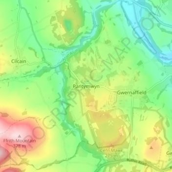
Name: Pantymwyn topographic map, elevation, terrain.
Location: Pantymwyn, Flintshire, Wales, CH7 5EH, United Kingdom (53.15252 -3.22664 53.19252 -3.18664)
Average elevation: 213 m
Minimum elevation: 113 m
Maximum elevation: 378 m
Thank you for supporting this site ❤️
Make a donation
Make a donation
Other topographic maps
Click on a map to view its topography, its elevation and its terrain.