
Thank you for supporting this site ❤️
Make a donation
Make a donation
Llandow topographic map
Click on the map to display elevation.
Thank you for supporting this site ❤️
Make a donation
Make a donation
About this map
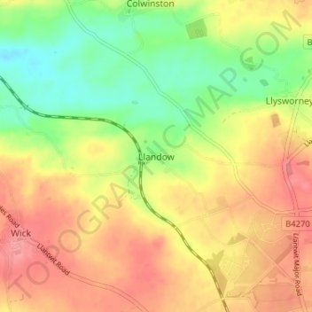
Name: Llandow topographic map, elevation, terrain.
Location: Llandow, Vale of Glamorgan, Wales, CF71 7NU, United Kingdom (51.42901 -3.54226 51.46901 -3.50226)
Average elevation: 69 m
Minimum elevation: 27 m
Maximum elevation: 104 m
Thank you for supporting this site ❤️
Make a donation
Make a donation
Other topographic maps
Click on a map to view its topography, its elevation and its terrain.
Thank you for supporting this site ❤️
Make a donation
Make a donation
Thank you for supporting this site ❤️
Make a donation
Make a donation
Cosmeston Lakes Country Park
United Kingdom > Wales > Vale of Glamorgan > Penarth
Average elevation: 26 m
Thank you for supporting this site ❤️
Make a donation
Make a donation
Thank you for supporting this site ❤️
Make a donation
Make a donation