
Thank you for supporting this site ❤️
Make a donation
Make a donation
Culat topographic map
Click on the map to display elevation.
Thank you for supporting this site ❤️
Make a donation
Make a donation
About this map
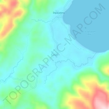
Name: Culat topographic map, elevation, terrain.
Location: Culat, Aurora, Central Luzon, Philippines (16.26933 122.15647 16.30933 122.19647)
Average elevation: 67 m
Minimum elevation: 0 m
Maximum elevation: 308 m
Thank you for supporting this site ❤️
Make a donation
Make a donation
Other topographic maps
Click on a map to view its topography, its elevation and its terrain.
Thank you for supporting this site ❤️
Make a donation
Make a donation
Thank you for supporting this site ❤️
Make a donation
Make a donation
Thank you for supporting this site ❤️
Make a donation
Make a donation