
Thank you for supporting this site ❤️
Make a donation
Make a donation
Águas Claras topographic map
Click on the map to display elevation.
Thank you for supporting this site ❤️
Make a donation
Make a donation
About this map
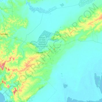
Name: Águas Claras topographic map, elevation, terrain.
Average elevation: 34 m
Minimum elevation: -1 m
Maximum elevation: 236 m
Thank you for supporting this site ❤️
Make a donation
Make a donation
Other topographic maps
Click on a map to view its topography, its elevation and its terrain.
Quilombo da Anastácia
Brasil > Rio Grande do Sul > Viamão > Quilombo da Anastácia
Average elevation: 9 m