
Thank you for supporting this site ❤️
Make a donation
Make a donation
Castelsarrasin topographic map
Click on the map to display elevation.
Thank you for supporting this site ❤️
Make a donation
Make a donation
Castelsarrasin
The western part of the commune lies in the Garonne Valley, which is an alluvial plain. The unbuildable nature of the land in this area is the reason why this part of the commune is not very urbanized. The town center and other, much more urbanized areas are located at a slightly higher altitude on the eastern slope of the valley, which allows them to be sheltered from the river's floods.
Thank you for supporting this site ❤️
Make a donation
Make a donation
About this map
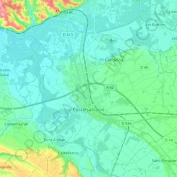
Name: Castelsarrasin topographic map, elevation, terrain.
Average elevation: 84 m
Minimum elevation: 62 m
Maximum elevation: 193 m
Thank you for supporting this site ❤️
Make a donation
Make a donation
Other topographic maps
Click on a map to view its topography, its elevation and its terrain.