
East topographic map
Click on the map to display elevation.
About this map
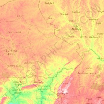
Name: East topographic map, elevation, terrain.
Location: East, Burkina Faso (9.65275 -1.72639 14.85275 3.47361)
Average elevation: 266 m
Minimum elevation: 99 m
Maximum elevation: 665 m
Other topographic maps
Click on a map to view its topography, its elevation and its terrain.
Upper-Basins
Most of Burkino Faso is a wide plateau formed by riverine systems and is called falaise de Banfora. There are three major rivers, the Red Volta, Black Volta and White Volta, which cuts through different valleys. The climate is generally hot, with unreliable rains across different seasons. Gold and quartz are…
Average elevation: 330 m