
Burg-Reuland topographic map
Interactive map
Click on the map to display elevation.
About this map
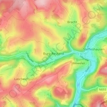
Name: Burg-Reuland topographic map, elevation, terrain.
Location: Burg-Reuland, Verviers, Luik, Wallonië, 4790, België (50.17675 6.11426 50.21675 6.15426)
Average elevation: 433 m
Minimum elevation: 338 m
Maximum elevation: 512 m
Other topographic maps
Click on a map to view its topography, its elevation and its terrain.
Oberhausen
België > Luik > Verviers > Burg-Reuland
Oberhausen, Burg-Reuland, Verviers, Luik, Wallonië, 4790, België
Average elevation: 433 m