
Make a donation
Gogogo topographic map
Click on the map to display elevation.
Make a donation
Gogogo
Mount Gorongosa is an inselberg in Sofala Province of central Mozambique. Its highest peak, Gogogo, reaches an elevation of 1,863 meters (6,112 feet). It was created by Karoo Volcanism.
Make a donation
About this map
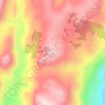
Name: Gogogo topographic map, elevation, terrain.
Location: Gogogo, Gorongosa, Sofala Province, Zona Centro, Mozambique (-18.40506 34.10585 -18.40496 34.10595)
Average elevation: 1,419 m
Minimum elevation: 1,167 m
Maximum elevation: 1,527 m
Make a donation
Other topographic maps
Click on a map to view its topography, its elevation and its terrain.
Gorongosa National Park
The park is in a 4,000-square-km section of the Great African Rift Valley system. The Rift extends from Ethiopia to central Mozambique. Massive tectonic shifts began forming the Rift about 30 million years ago. Other warpings, uplifts, and sinkings of the Earth's crust over millennia shaped the plateaus on…
Average elevation: 125 m
Make a donation