
Make a donation
Redding topographic map
Click on the map to display elevation.
Make a donation
Redding
Redding's topography is dominated by three ridges, running north to south, with intervening valleys featuring steep slopes and rocky ledges in some sections. The highest elevation is about 830 feet above sea level, on Sunset Hill in the northeast part of the town; and the low elevation is about 290 feet above sea level at the Saugatuck Reservoir along the southern border.
Make a donation
About this map
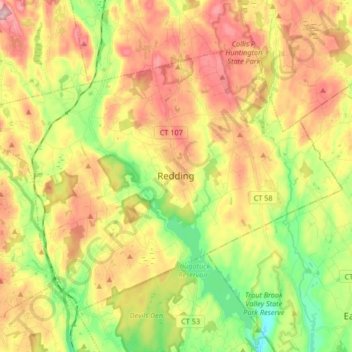
Name: Redding topographic map, elevation, terrain.
Average elevation: 160 m
Minimum elevation: 37 m
Maximum elevation: 292 m
Make a donation
Other topographic maps
Click on a map to view its topography, its elevation and its terrain.
Glenville
United States > Connecticut > Western Connecticut Planning Region > Greenwich
Average elevation: 54 m
South End
United States > Connecticut > Western Connecticut Planning Region > Stamford
Average elevation: 11 m