
Thank you for supporting this site ❤️
Make a donation
Make a donation
Givatayim topographic map
Click on the map to display elevation.
Thank you for supporting this site ❤️
Make a donation
Make a donation
About this map
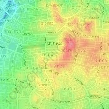
Name: Givatayim topographic map, elevation, terrain.
Location: Givatayim, Tel Aviv Subdistrict, Tel-Aviv District, Israel (32.05843 34.79786 32.08188 34.82074)
Average elevation: 44 m
Minimum elevation: 3 m
Maximum elevation: 81 m
Thank you for supporting this site ❤️
Make a donation
Make a donation
Other topographic maps
Click on a map to view its topography, its elevation and its terrain.