
Thank you for supporting this site ❤️
Make a donation
Make a donation
Le Murat topographic map
Click on the map to display elevation.
Thank you for supporting this site ❤️
Make a donation
Make a donation
About this map
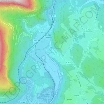
Name: Le Murat topographic map, elevation, terrain.
Average elevation: 374 m
Minimum elevation: 240 m
Maximum elevation: 943 m
Thank you for supporting this site ❤️
Make a donation
Make a donation
Other topographic maps
Click on a map to view its topography, its elevation and its terrain.
Thank you for supporting this site ❤️
Make a donation
Make a donation
Étang des Vosges
France > Auvergne-Rhône-Alpes > Ain > Saint-Germain-sur-Renon > La Maison Neuve
Average elevation: 274 m
Thank you for supporting this site ❤️
Make a donation
Make a donation
Ochiaz
France > Auvergne-Rhône-Alpes > Ain > Valserhône > Châtillon-en-Michaille
Average elevation: 719 m
Thank you for supporting this site ❤️
Make a donation
Make a donation
Thank you for supporting this site ❤️
Make a donation
Make a donation