
Thank you for supporting this site ❤️
Make a donation
Make a donation
La Escaleruela topographic map
Click on the map to display elevation.
Thank you for supporting this site ❤️
Make a donation
Make a donation
About this map
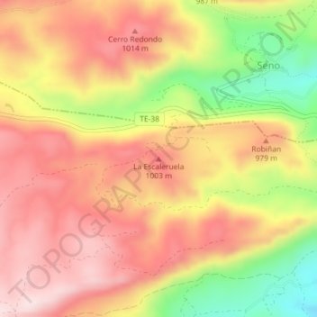
Name: La Escaleruela topographic map, elevation, terrain.
Location: La Escaleruela, Castellote, Maestrazgo, Teruel, Aragón, España (40.80466 -0.35022 40.80476 -0.35012)
Average elevation: 923 m
Minimum elevation: 712 m
Maximum elevation: 1,062 m
Thank you for supporting this site ❤️
Make a donation
Make a donation