
Teufen (AR) topographic map
Interactive map
Click on the map to display elevation.
About this map
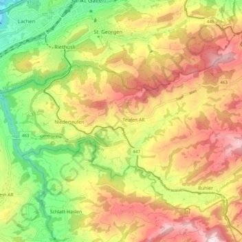
Name: Teufen (AR) topographic map, elevation, terrain.
Location: Teufen (AR), Mittelland, Appenzell Rhodes-Extérieures, Suisse (47.37706 9.33968 47.40771 9.43600)
Average elevation: 855 m
Minimum elevation: 594 m
Maximum elevation: 1,114 m
Other topographic maps
Click on a map to view its topography, its elevation and its terrain.
Gais
Suisse > Appenzell Rhodes-Extérieures > Mittelland
Gais, Mittelland, Appenzell Rhodes-Extérieures, 9056, Suisse
Average elevation: 1,005 m
Trogen
Suisse > Appenzell Rhodes-Extérieures > Mittelland
Trogen, Mittelland, Appenzell Rhodes-Extérieures, 9043, Suisse
Average elevation: 956 m
Zwislen
Suisse > Appenzell Rhodes-Extérieures > Mittelland > Gais > Zwislen
Zwislen, Gais, Mittelland, Appenzell Rhodes-Extérieures, 9056, Suisse
Average elevation: 986 m
Sitter
Suisse > Appenzell Rhodes-Extérieures > Mittelland
Sitter, Mittelland, Appenzell Rhodes-Extérieures, 8589, Suisse
Average elevation: 763 m