
Thank you for supporting this site ❤️
Make a donation
Make a donation
Herd Island topographic map
Click on the map to display elevation.
Thank you for supporting this site ❤️
Make a donation
Make a donation
About this map
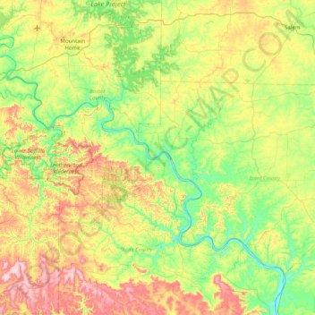
Name: Herd Island topographic map, elevation, terrain.
Location: Herd Island, Stone County, Arkansas, United States (35.78507 -92.48571 36.42507 -91.84571)
Average elevation: 239 m
Minimum elevation: 81 m
Maximum elevation: 549 m
Thank you for supporting this site ❤️
Make a donation
Make a donation
Other topographic maps
Click on a map to view its topography, its elevation and its terrain.