
Make a donation
Gala topographic map
Click on the map to display elevation.
Make a donation
About this map
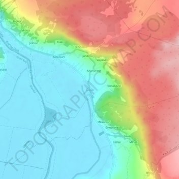
Name: Gala topographic map, elevation, terrain.
Location: Gala, Općina Otok, Split-Dalmatia County, 21241, Croatia (43.69327 16.70782 43.73327 16.74782)
Average elevation: 376 m
Minimum elevation: 292 m
Maximum elevation: 505 m
Make a donation
Other topographic maps
Click on a map to view its topography, its elevation and its terrain.
Hvar
Croatia > Split-Dalmatia County
The island has a typical Mediterranean vegetation, mostly bare with woody scrub at higher, steeper elevations, turning to pine forests on the lower slopes with Holm oak (Orno-Quercetum ilicis), Aleppo pines (Pinus halapensis Mill) and Black pines (Pinus nigra dalmatica). The islet of Šćedro is especially…
Average elevation: 58 m
Make a donation
Make a donation
Make a donation
Make a donation
Make a donation
Općina Klis
Croatia > Split-Dalmatia County
The Klis mountain pass separates the mountains Mosor and Kozjak at an altitude of 360m. It has had major strategic value throughout history because any inland force passing through Klis would have been able to easily reach the entire region of Split and Kaštela.
Average elevation: 466 m
Make a donation
Make a donation
Make a donation
Make a donation
Make a donation
Make a donation
Make a donation
Make a donation
Make a donation