
Peltre topographic map
Interactive map
Click on the map to display elevation.
About this map
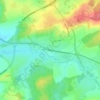
Name: Peltre topographic map, elevation, terrain.
Average elevation: 207 m
Minimum elevation: 176 m
Maximum elevation: 258 m
Other topographic maps
Click on a map to view its topography, its elevation and its terrain.
Sarrebourg
Sarrebourg, Sarrebourg-Château-Salins, Moselle, Grand Est, France métropolitaine, 57400, France
Average elevation: 273 m
Gondrexange
Gondrexange, Sarrebourg-Château-Salins, Moselle, Grand Est, France métropolitaine, 57815, France
Average elevation: 286 m
Sentier du Moulin
France > Grand Est > Moselle > Pagny-lès-Goin
Sentier du Moulin, Pagny-lès-Goin, Metz, Moselle, Grand Est, France métropolitaine, 57420, France
Average elevation: 234 m
Plappeville
Plappeville, Metz, Moselle, Grand Est, France métropolitaine, 57050, France
Average elevation: 260 m
Volmerange-les-Mines
Volmerange-les-Mines, Thionville, Moselle, Grand Est, France métropolitaine, 57330, France
Average elevation: 350 m
Prévocourt
Prévocourt, Sarrebourg-Château-Salins, Moselle, Grand Est, France métropolitaine, 57590, France
Average elevation: 266 m
Saint-Georges
Saint-Georges, Sarrebourg-Château-Salins, Moselle, Grand Est, France métropolitaine, 57830, France
Average elevation: 306 m
Saint-Hubert
Saint-Hubert, Metz, Moselle, Grand Est, France métropolitaine, 57640, France
Average elevation: 261 m
Ars-sur-Moselle
Ars-sur-Moselle, Metz, Moselle, Grand Est, France métropolitaine, 57130, France
Average elevation: 244 m
Moulins-lès-Metz
Moulins-lès-Metz, Metz, Moselle, Grand Est, France métropolitaine, 57160, France
Average elevation: 178 m