
Biteng topographic map
Interactive map
Click on the map to display elevation.
About this map
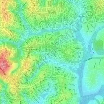
Name: Biteng topographic map, elevation, terrain.
Location: Biteng, Yaoundé IV, Yaoundé, Mfoundi, Centre, Cameroun (3.84297 11.55099 3.85584 11.56943)
Average elevation: 718 m
Minimum elevation: 681 m
Maximum elevation: 783 m
Other topographic maps
Click on a map to view its topography, its elevation and its terrain.
Yaoundé
La ville de Yaoundé est située au sud de la Région du Centre et est éloignée de 250 km à l'est des côtes de la baie de Biafra. Ce site de collines se décompose en trois unités topographiques inscrites dans un socle rocheux de gneiss précambrien : la barrière d'inselbergs au Nord-Ouest dominée par…
Average elevation: 717 m