
Make a donation
Broga topographic map
Click on the map to display elevation.
Make a donation
Broga
The hill, approximately 400 m (1,300 ft) in altitude, is notable for its unique appearance as it is rather devoid of trees, which is an uncommon sight amongst the tropical rainforests surrounding the region. Cogongrass typically dominates the summit area. Remnants of burnt out tree trunks indicate that the area may have been ravaged by a forest fire and the trees did not regrow.
Make a donation
About this map
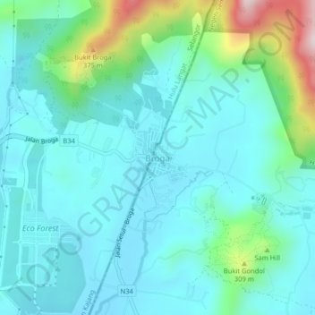
Name: Broga topographic map, elevation, terrain.
Location: Broga, Seremban, Negeri Sembilan, 71750, Malaysia (2.91660 101.89120 2.95660 101.93120)
Average elevation: 141 m
Minimum elevation: 50 m
Maximum elevation: 520 m
Make a donation
Other topographic maps
Click on a map to view its topography, its elevation and its terrain.
Jelebu
Amongst the seven districts of Negeri Sembilan, Jelebu is the most mountainous topographically as the Titiwangsa Mountains, the longest mountain range in Malaysia, transverses through the district. As a result, most of its terrain are dominated by forested undulating hills and mountain peaks. The Titiwangsa…
Average elevation: 307 m
Make a donation
Make a donation
Make a donation
Make a donation
Perkampungan Budaya Terachi
Malaysia > Negeri Sembilan > Kampung Ayer Hitam > Kampung Parit Istana
Average elevation: 128 m
Make a donation
Make a donation
Jelebu
Amongst the seven districts of Negeri Sembilan, Jelebu is the most mountainous topographically as the Titiwangsa Mountains, the longest mountain range in Malaysia, transverses through the district. As a result, most of its terrain are dominated by forested undulating hills and mountain peaks. The Titiwangsa…
Average elevation: 307 m
Make a donation
Make a donation
Make a donation
Make a donation
Make a donation
Make a donation
Make a donation