
Thank you for supporting this site ❤️
Make a donation
Make a donation
Cerro Silvestre topographic map
Click on the map to display elevation.
Thank you for supporting this site ❤️
Make a donation
Make a donation
About this map
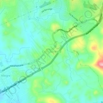
Name: Cerro Silvestre topographic map, elevation, terrain.
Location: Cerro Silvestre, Distrito Arraiján, Panamá Oeste, 1001, Panamá (8.91865 -79.70102 8.95865 -79.66102)
Average elevation: 57 m
Minimum elevation: 11 m
Maximum elevation: 186 m
Thank you for supporting this site ❤️
Make a donation
Make a donation
Other topographic maps
Click on a map to view its topography, its elevation and its terrain.
Altos del Naranjal
Panamá > Panamá Oeste > Distrito Arraiján > Altos del Naranjal
Average elevation: 69 m