
Thank you for supporting this site ❤️
Make a donation
Make a donation
Bohmte topographic map
Click on the map to display elevation.
Thank you for supporting this site ❤️
Make a donation
Make a donation
About this map
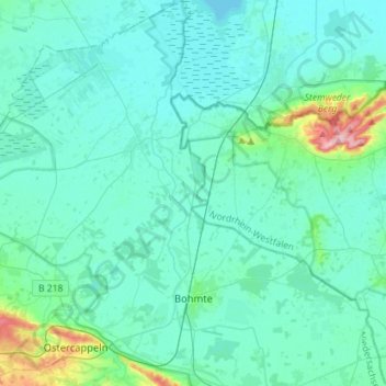
Name: Bohmte topographic map, elevation, terrain.
Location: Bohmte, Landkreis Osnabrück, Nedersaksen, 49163, Duitsland (52.32705 8.17762 52.50035 8.39239)
Average elevation: 53 m
Minimum elevation: 34 m
Maximum elevation: 190 m
Thank you for supporting this site ❤️
Make a donation
Make a donation
Other topographic maps
Click on a map to view its topography, its elevation and its terrain.
Thank you for supporting this site ❤️
Make a donation
Make a donation
Kloster Oesede
Duitsland > Nedersaksen > Landkreis Osnabrück > Georgsmarienhütte > Kloster Oesede
Average elevation: 125 m