
Thank you for supporting this site ❤️
Make a donation
Make a donation
Cheakamus River topographic map
Click on the map to display elevation.
Thank you for supporting this site ❤️
Make a donation
Make a donation
About this map
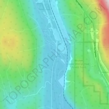
Name: Cheakamus River topographic map, elevation, terrain.
Average elevation: 266 m
Minimum elevation: 49 m
Maximum elevation: 879 m
Thank you for supporting this site ❤️
Make a donation
Make a donation
Other topographic maps
Click on a map to view its topography, its elevation and its terrain.
Stawamus Chief Provincial Park
Canada > British Columbia > Squamish-Lillooet Regional District > Squamish
Average elevation: 433 m
Watts Point
Canada > British Columbia > Squamish-Lillooet Regional District > Squamish
Average elevation: 44 m
The Galapagos Islands Boulder
Canada > British Columbia > Squamish-Lillooet Regional District > Squamish
Average elevation: 289 m
The Galapagos Islands Boulder
Canada > British Columbia > Squamish-Lillooet Regional District > Squamish
Average elevation: 289 m
Thank you for supporting this site ❤️
Make a donation
Make a donation