Geolocate
👉 Easily get elevation data in JSON, GeoTIFF and KML formats using Elevation API
Thank you for supporting this site ❤️
Make a donation

Shorewood topographic map

Click on the map to display elevation.

👉 Easily get elevation data in JSON, GeoTIFF and KML formats using Elevation API
Thank you for supporting this site ❤️
Make a donation

About this map

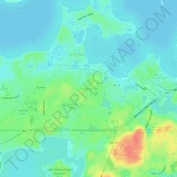
Name: Shorewood topographic map, elevation, terrain.

Location: Shorewood, Tonka Bay, Hennepin County, Minnesota, 55331, United States (44.88080 -93.60912 44.92080 -93.56912)

Average elevation: 293 m

Minimum elevation: 280 m

Maximum elevation: 330 m

Other topographic maps

Click on a map to view its topography, its elevation and its terrain.

Tonka Bay

United States > Minnesota > Hennepin County

Average elevation: 286 m

Woodland

United States > Minnesota > Hennepin County

Average elevation: 287 m

Loretto

United States > Minnesota > Hennepin County

Average elevation: 309 m

Independence

United States > Minnesota > Hennepin County

Average elevation: 298 m

Greenwood

United States > Minnesota > Hennepin County

Average elevation: 289 m

Corcoran

United States > Minnesota > Hennepin County

Average elevation: 292 m

Kenwood

United States > Minnesota > Hennepin County > Minneapolis

Average elevation: 268 m

Greenfield

United States > Minnesota > Hennepin County

Average elevation: 303 m

Excelsior

United States > Minnesota > Hennepin County

Average elevation: 292 m

Medina

United States > Minnesota > Hennepin County

Average elevation: 304 m

Deephaven

United States > Minnesota > Hennepin County

Average elevation: 288 m