
Thank you for supporting this site ❤️
Make a donation
Make a donation
Lasbela District topographic map
Click on the map to display elevation.
Thank you for supporting this site ❤️
Make a donation
Make a donation
About this map
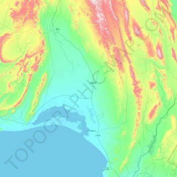
Name: Lasbela District topographic map, elevation, terrain.
Location: Lasbela District, Balochistan, Pakistan (25.05000 65.88333 26.45000 67.28333)
Average elevation: 245 m
Minimum elevation: -2 m
Maximum elevation: 1,378 m
Thank you for supporting this site ❤️
Make a donation
Make a donation
Other topographic maps
Click on a map to view its topography, its elevation and its terrain.
Thank you for supporting this site ❤️
Make a donation
Make a donation
Thank you for supporting this site ❤️
Make a donation
Make a donation
Thank you for supporting this site ❤️
Make a donation
Make a donation